_edi.png)
Our Projects
Project Summary: The Abu Khusheiba Copper and Gold Project comprises two exploration license blocks located in the Wadi Araba Region, adjacent to the Aqaba-Dead Sea Highway. The project is situated within a historically productive copper district and targets sandstone-hosted red-bed copper mineralization of Cambrian age and Basement-hosted gold-copper mineral systems.
Location and Access: The project consists of two blocks located approximately 6 km apart.
Block 1
-
Area: ~ 48.9 km2
-
Dimensions: ~ 10.8 km × 9.79 km
-
Location: - ~79 km north of Aqaba Airport - ~84.5 km north of Aqaba City - ~87.5 km north of the Red Sea coastline
-
Access time from Amman via the Aqaba-Dead Sea Highway is approximately 2.5-3 hours.
Block 2
-
Area: ~18.0 km2
-
Dimensions: ~2.27 km x 8.93 km, with a total area of about 18.0 km2.
-
Located approximately 6 km south of Block 1.

The main paved Aqaba-Dead Sea Highway lies approximately 2.5 km west of Block 1. A secondary paved road branches from the highway and traverses the western, central, and northern parts of Block 1. Remaining areas are accessible via unsealed tracks and wadis suitable for four-wheel-drive vehicles.
Infrastructure and Services:
The project area is well served by regional infrastructure:
-
Grid power and telecommunications cover the entire region
-
Sealed and unsealed road networks provide year-round access.
Several dams capture seasonal runoff for agricultural and local use.
Risha Village, located approximately 9 km west-southwest of the project, provides basic services including a clinic, police station, civil defense center, retail outlets, and restaurants. Wadi Musa (Petra), located east of the project area, offers comprehensive facilities including hospitals, banks, hotels, and commercial services. Aqaba City, located on the Red Sea coast (population >100,000), is serviced by Aqaba Airport with scheduled domestic flights and limited regional commercial services.
Tenure and Ownership:
The Abu Khusheiba Project is covered by Exploration License 2025/964, which was granted on 21 July 2025 by the Energy and Minerals Regulatory Commission (EMRC). The tenement covers an area of approximately 48.9 km².
The exploration license is valid for an initial term of up to 30 years - to be renewed on a yearly basis - subject to extension in accordance with applicable mining legislation and mutual agreement with the granting authority. At the time of reporting, the tenement is in good standing, with all statutory reporting and expenditure requirements satisfied.
Wadi Araba Minerals holds a 100% legal and beneficial interest in the exploration license, and there are no encumbrances, royalties, farm-in agreements, or third-party interests affecting the Project that would materially impact exploration activities.
Paleozoic Stratiform Copper Mineralization
Geological Setting
The Abu Khusheiba Copper Project is located at the northern margin of the Arabian plate near the boundary with the Sub-African Plate and is structurally influenced by the regional Dead Sea Transform Fault System (DSTS).
During the Neoproterozoic to Early Cambrian, the region formed part of a stable continental shelf along a passive margin. Paleogeographic reconstruction indicates that the area was located at mid- to high latitudes, experiencing Late Ordovician glaciation before northward plate migration commenced during the Silurian. The region reached its current low-latitude position during the Paleocene.
Local Geology
Exposed rock units in the project area range in age from Neoproterozoic (~860-550 Ma) to Early Middle Paleozoic (Cambrian, Ordovician and Devonian), with Quaternary alluvial deposits present within low-relief wadis.
Neoproterozoic basement rocks comprise two major crystalline complexes:
• Aqaba Complex
• Araba Complex.
These complexes are separated by a regionally recognized unconformity related to changes in tectonic regime.
Cambrian sandstones have been subdivided into eight informal units (cb1 to cb8). The principal host to copper mineralization is the CB3 unit, which comprises cross-bedded ine-grained sandstones of grayish-white to whitish-pink color, with resistant interbedded sandstone horizons containing red porphyritic fragments.

Mineralization
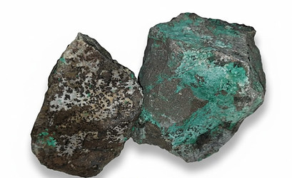
This project targets stratiform copper mineralization hosted within Paleozoic sandstone sequences, interpreted to comprise both hydrothermal stratiform and red-bed-style copper deposits. Copper mineralization is expressed by secondary copper minerals, including malachite, chrysocolla, atacamite, and azurite, consistent with oxidized near-surface conditions.
Copper mineralization occurs as:
• Stratabound nodular malachite and chrysocolla
• Disseminated chrysocolla
• Fracture-controlled and brecciated malachite and chalcocite infill


Historical Mining
The Wadi Araba Region is a historically significant copper mining district, with documented extraction activities dating back to the Iron Age and continuing through Pharaonic, Nabataean, Roman, Byzantine, and Islamic periods. Historical workings are present across multiple locations in the Wadi Araba region, with correlating mineralized trends extending into adjacent areas.


.jpg)
Exploration and Drilling
Exploration drilling completed at the Abu Khusheiba Copper Project, historical and recent, includes:
• 117 core drill holes
• Total drilled length of 5,611 meters.
Drilling confirmed the presence of structurally displaced copper mineralization and identified additional mineralized zones in Sectors 1 and 2 within the project area.
Mineral Resource Estimate
A Mineral Resource Estimate has been completed for the Abu Khusheiba Copper Project in accordance with the JORC Code (2012).
Indicated Mineral Resource
• Cut-off grade: 0.15% Cu
• Mineralized horizon: cb3

As of January 2026, the Mineral Resource was delineated and reported at the Indicated classification, totaling 9.4 Mt at an average grade of 0.50% Cu, containing approximately 46,348 tonnes of copper. Drilling to date covers approximately 15% of the interpreted prospective structural blocks, indicating significant potential for resource expansion through systematic step-out and infill drilling.


(The Mineral Resource has been estimated in accordance with applicable reporting standards; further work is required to establish Ore Reserves.)


The resource has been classified as indicated based on drilling density, geological continuity, and data quality. No Ore Reserves have been declared.


Sampling, Assaying and QA/QC
Quality assurance and quality control procedures were applied throughout the drilling and sampling programs.
• Insertion rates:
- 1 in 20 blanks
- 1 in 20 certified reference materials (CRMs)
- 1 in 20 field duplicates
• Acceptance Criteria:
- Blanks: <5× detection limit
- CRMs: within ±2 standard deviations of certified value
- Duplicates: RSD <10–15% for copper values above detection limits.
Samples were assigned QA/QC lags (PASS, WARN, FAIL, RE-RUN) and investigated where results fell outside acceptable tolerance limits.

Basement-Hosted Gold-Copper Mineral Systems
January 05, 2026
Overview Within the Abu Khusheiba Project area, a basement-hosted gold-copper mineral system has been identified within Neoproterozoic crystalline basement rocks and associated intrusive and volcanic sequences. The system is interpreted, based on geological and geochemical observations, to represent a reduced intrusion-related gold system (RIRGS) transitional toward a porphyry-style system.
Volcanic rocks, particularly red porphyry andesite, are spatially and genetically associated with mineralization and are interpreted to play an important role in the development of low-sulphidation (LS) epithermal gold mineralization observed within the project area.
The basement-hosted system is interpreted to represent the primary mineralizing source for overlying and laterally displaced secondary mineral systems, including stratiform sandstone-hosted copper and LS epithermal mineralization.

To date, no Mineral Resources or Ore Reserves have been defined for this system.
Geological and Tectonic Setting
The mineral system occurs within Neoproterozoic crystalline basement rocks intruded by reduced calc-alkaline granodiorite to granite bodies and associated volcanic units.


The regional tectonic setting is interpreted as an extensional back-arc, post-collisional environment, favorable for the emplacement of reduced intrusions, volcanic activity, and the development of long-lived hydrothermal systems.
Mineral System Interpretation
Geological mapping, alteration studies, and geochemical signatures support interpretation of a vertically and laterally extensive hydrothermal system linking intrusive, volcanic, and sedimentary host rocks.
Interpreted System Characteristics

Mineralization Style and Controls
Mineralization is interpreted to be structurally controlled and associated with:
-
Contacts between intrusions and basement rocks
-
Faults and fracture networks • Volcanic centers and volcanic–intrusive interfaces
_edited.jpg)
Low-sulphidation epithermal gold mineralization is interpreted to be preferentially developed within and adjacent to red porphyry andesite volcanic units, reflecting focused liquid, boiling, and metal deposition at shallow crustal levels.
The stratiform sandstone-hosted copper mineralization and LS epithermal gold occurrences elsewhere in the project area are interpreted as secondary expressions of this deeper, basement-hosted mineralizing system.

Exploration Status
The basement-hosted gold–copper system is at an early stage of exploration and is currently defined through surface mapping, geochemical sampling, and mineral system analysis. As such, it presents a compelling exploration target with potential to support district-scale mineral development.
Wadi Araba Minerals continues to apply disciplined, data-driven exploration methodologies aimed at advancing these assets toward resource definition while maintaining compliance with recognized industry standards, including the JORC Code.
Planned Exploration Activities
Upcoming exploration programs are designed to further evaluate the basement-hosted gold–copper system and its relationship to volcanic and sedimentary-hosted mineralization. Planned activities include integrated geological, geochemical, and geophysical studies, followed by targeted drilling to test interpreted intrusive, volcanic, and structural controls.
Relationship to Other Mineral Systems
The basement-hosted gold–copper system is interpreted to act as the primary hydrothermal source for mineralization within the Abu Khusheiba Project area. Overlying sandstone-hosted copper (cb3 unit) and LS epithermal gold mineralization are interpreted to represent higher-level and laterally displaced expressions of this system, with volcanic units, particularly red porphyry andesite, playing a key role in localizing epithermal mineralization.


